Connectivity between McDaniel Farm and Shorty Howell Park; The Loop Trail
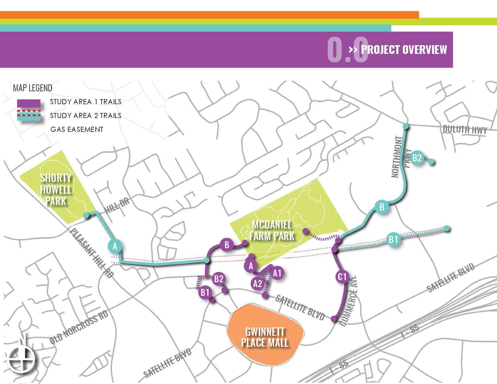
In order to achieve greater walkability in the district, Gwinnett Place CID envisions a strategy for connecting residential, commercial and recreational destinations in the greater Gwinnett Place area. The Gwinnett Place CID has proposed a network of trails to increase walkability and improve the pedestrian experience in the immediate Gwinnett Place area and also complete a section of the Gwinnett County’s Greenway system. By creating safer, more scenic and direct pedestrian routes, along with providing added transportation options to reduce vehicular traffic, these trails can help spark redevelopment in Gwinnett Place.
The project goals for connecting the Gwinnett Place commercial area to McDaniel Farm and Shorty Howell Park are to:
- Increase walkability between key residential, commercial and recreational destinations, to spur redevelopment in the Gwinnett Place area
- Connect Gwinnett Place to the larger network of Gwinnett County greenways and open space, to provide alternative transportation options to destinations throughout the county
- Create a safe and enjoyable experience along the entirety of the trail system, and to encourage walking and biking as transportation alternatives
- View Gwinnett Place Connected Plan
Gwinnett County, the Atlanta Regional Commission, Sugarloaf CID and Gwinnett Place CID completed the Loop Trail study, a conceptional document with trail alignments, typical sections, cost estimates, and a project deliverability plan to position the project for future funding opportunities. There is a significant need for a comprehensive planning effort for alternative mode transportation that connects activity centers, including the Gwinnett Place area, Gas South District and associated future mixed-use developments, Shorty Howell Park, McDaniel Farm Park, Peachtree Ridge Park, Suwanee Creek Greenway, and Western Gwinnett Pathway as well as future transit routes. This planning study will evaluate a 17-mile trail to encompass these areas and provide both recreational and transportation infrastructure that will reduce the number of vehicular trips in this growing area. Click here to read the report.
Pleasant Hill Road Streetscape Projects
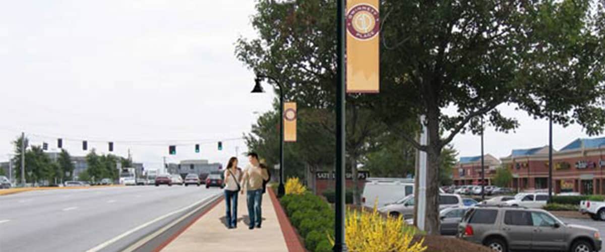 With grants provided by the Georgia Department of Transportation combined with Gwinnett County SPLOST and CID funds, five phases of streetscape improvement projects have been constructed along portions of Pleasant Hill Road from Old Norcross Road to Club Drive. The projects feature enhanced landscaping, installation of new curb and gutter, benches, pedestrian plazas, bus shelters, brick pavers, trash receptacles, ADA compliant ramps and accompanying drainage structures. Streetlights were installed from Satellite Boulevard to Club Drive.
Satellite Boulevard Streetscape Projects
Two phases of the Satellite Boulevard streetscape projects have been completed with funding from the Georgia Department of Transportation, Gwinnett County and the CID. Phase one enhanced the streetscape from the Gwinnett County Transit Center to Tandy Key Lane, and phase two enhanced Pleasant Hill Road to Old Norcross Road. New LED streetlights were recently installed along Satellite Boulevard from Steve Reynolds Boulevard to Pleasant Hill Road, and also along portions of Pleasant Hill Road and Steve Reynolds Boulevard. Preliminary engineering and streetscape construction plans have been developed for the remaining portions of Satellite Boulevard, from Old Norcross Road to Steve Reynolds Boulevard. Plans to construct any additional streetscape projects along Satellite Boulevard are on hold until final decisions are made regarding potential bus rapid transit (BRT) connectivity along the Satellite Boulevard corridor.
New Sidewalks
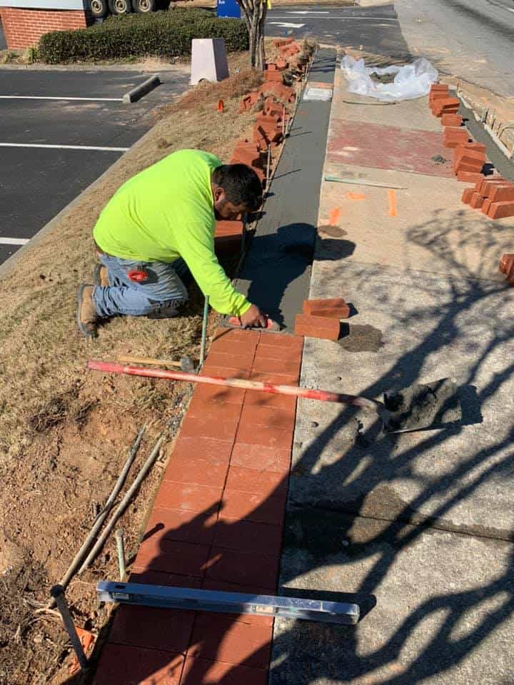 In partnership with Gwinnett County, the Gwinnett Place CID has added approximately 17 miles of new sidewalk and associated landscaping improvement projects along:
- Venture Parkway
- Market Street
- Crestwood Parkway
- Satellite Boulevard
- Old Norcross Road
- Steve Reynolds Boulevard
- Merchants Way
- Koger Boulevard
- Pineland Road
- Sweetwater Road
- Pleasant Hill Road
- Tandy Key Lane
- Commerce Avenue
- Liddell Lane
- East Liddell Lane
- Venture Drive
- West Liddell Road