Pleasant Hill Road at I-85 Interchange
While the Pleasant Hill Road at I-85 Diverging Diamond Interchange (DDI) continues to function efficiently today, as traffic continues to grow on Pleasant Hill Road, traffic levels will begin to exceed the DDI’s capacity. Later this decade, the DDI’s operation will become unstable with an unacceptable level of service. As a large-scale project will be necessary to accommodate growth and federally funded projects are currently expected to take seven to 10 years, efforts are beginning to visualize the future of Pleasant Hill Road and the interchange with I-85.
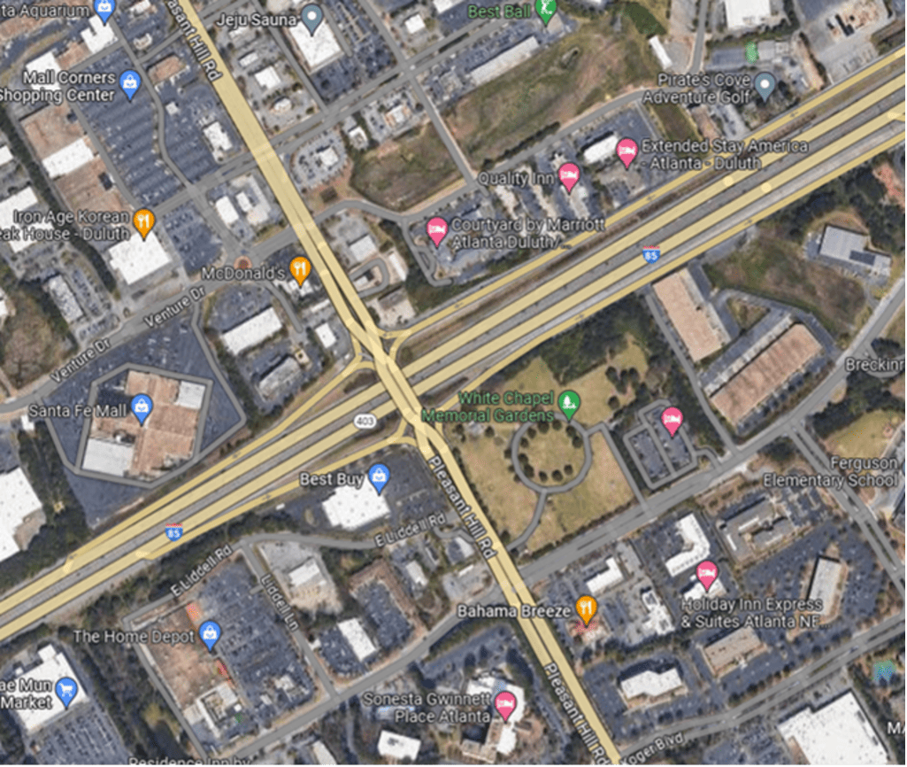
Currently, the Gwinnett Place CID is preparing conceptual layouts, traffic analysis, potential right-of-way impacts and cost estimates for a series of improvements in the area of Pleasant Hill Road and I-85. In partnership with Gwinnett County, the CID is looking to move improvement solution alternatives forward with detailed information that would guide discussions and be used in applications for funding requests.
Identified design alternatives include:
- Transforming Pleasant Hill Road into a “super street” with improvements to various intersections from Old Norcross Road to Club Drive
- Determining long-term improvements to the interchange such as constructing a Single Point Urban Interchange (SPUI) or a larger DDI
- Adding greater capacity for the I-85 collector-distributor (CD) lanes
- Constructing an Old Norcross Road early off-ramp
- Constructing a Venture Parkway early off-ramp
- Improving the Koger Boulevard/Crestwood Parkway intersection
Connected Vehicle (CV) Integration and Deployment for Gwinnett Place
The Georgia Department of Transportation’s (GDOT) Regional Connected Vehicle (CV) Program is an opportunity for the CID to help improve safety and allow for better traffic management within the Gwinnett Place area. The CID’s participation in this program will result in connected vehicle roadside units (RSUs) being installed in 45 traffic signals along Pleasant Hill Road, Satellite Boulevard, Club Drive, Steve Reynolds Boulevard and Old Norcross Road. The RSUs are necessary to broadcast safety messages to vehicles equipped to receive those messages. As a funding partnership with GDOT and the Gwinnett County Department of Transportation, the CID is contributing funds to the program to equip intersections within Gwinnett’s central business district. The purpose of the project is to provide for connectivity for first responders and all road users by reducing vehicle travel time. The anticipated project completion date is spring 2023.
Satellite Boulevard at Pleasant Hill Road Intersection Improvement Project
The CID will further explore additional intersection design alternatives to improve the congested Satellite Boulevard at Pleasant Hill Road interchange. Currently operating at a Level of Service (LOS) D, traffic studies show that an increase of vehicular activity will likely cause the intersection to fail – addressing other operations along the corridor will not avoid or ameliorate this situation. The resulting intersection improvement project will provide a major capacity improvement and positions the intersection for future travel demand at a central location in the CID. The goal of the analysis and initial preliminary engineering will be to to identify a preferred alternative that best accommodates future traffic demand at the intersection of Pleasant Hill Road and Satellite Boulevard while creating a sense of place for the Gwinnett Place area and promoting a safe walkable environment.
Connectivity between McDaniel Farm and Shorty Howell Park; The Loop Trail
In order to achieve greater walkability in the district, Gwinnett Place CID envisions a strategy for connecting residential, commercial and recreational destinations in the greater Gwinnett Place area. The Gwinnett Place CID has proposed a network of trails to increase walkability and improve the pedestrian experience in the immediate Gwinnett Place area and also complete a section of the Gwinnett County’s Greenway system. By creating safer, more scenic and direct pedestrian routes, along with providing added transportation options to reduce vehicular traffic, these trails can help spark redevelopment in Gwinnett Place.
The project goals for connecting the Gwinnett Place commercial area to McDaniel Farm and Shorty Howell Park are to:
- Increase walkability between key residential, commercial and recreational destinations, to spur redevelopment in the Gwinnett Place area
- Connect Gwinnett Place to the larger network of Gwinnett County greenways and open space, to provide alternative transportation options to destinations throughout the county
- Create a safe and enjoyable experience along the entirety of the trail system, and to encourage walking and biking as transportation alternatives
- View Gwinnett Place Connected Plan
In March 2021, Gwinnett County, the Atlanta Regional Commission, Sugarloaf CID and Gwinnett Place CID completed the Loop Trail study, a conceptional document with trail alignments, typical sections, cost estimates, and a project deliverability plan to position the project for future funding opportunities. There is a significant need for a comprehensive planning effort for alternative mode transportation that connects activity centers, including the Gwinnett Place area, Gas South District and associated future mixed-use developments, Shorty Howell Park, McDaniel Farm Park, Peachtree Ridge Park, Suwanee Creek Greenway, and Western Gwinnett Pathway as well as future transit routes. This planning study evaluated a 17-mile trail to encompass these areas and provide both recreational and transportation infrastructure that will reduce the number of vehicular trips in this growing area. Click here to read the report.
Area-wide Traffic Responsive System
The Gwinnett Place area traffic system consists of 49 signalized intersections with primary corridors including Pleasant Hill Road, Satellite Boulevard, Steve Reynolds Boulevard, and Club Drive. The Gwinnett Place system also includes two interchanges with I-85, a half diamond at Steve Reynolds Boulevard and a diverging diamond interchange (DDI) at Pleasant Hill Road. Pleasant Hill Road includes 23 intersections and is bound by an interchange on either end of the corridor, SR 13/Buford Highway to the north and Ronald Reagan Parkway to the south. Pleasant Hill Road maintains heavy volumes throughout day with additional commuter travel during the peaks. Satellite Boulevard includes 14 intersections and is parallel to I-85. It is a popular alternate route to I-85 with heavy peaks during the AM and PM. Steve Reynolds Boulevard, combined with Club Drive, are a popular alternative route to Pleasant Hill Road as it circumvents some of the congestion surrounding Gwinnett Place Mall. This route consists of 10 intersections.
Traffic Responsive Signal control systems (TR) are useful in areas with heavy traffic volumes and unpredictable traffic patterns. The system reacts to changes in traffic demand and then implements timing plans most suited for the traffic conditions. It works well along popular alternative or bypass routes that are impacted by weather, incidents, seasonal variations, or planned special events. The Gwinnett Place system is an ideal location for a TR system because of the heavy and often variable volumes along Pleasant Hill Road, alternate route options for I-85 and Pleasant Hill Road, and volume variation on weekends due to traffic generated by area retail. The goal for the Gwinnett Place TR system is to run the most suitable traffic control patterns based on traffic volumes.
Gwinnett Place Drive/Mall Boulevard Complete Street Projects
As outlined in the ACTivate Gwinnett Place plan, the CID has prepared construction plans to transform Mall Boulevard and Gwinnett Place Drive into complete streets. The designs call for reducing vehicular traffic lanes to transition space within the existing right-of-way to provide sidewalks, green space and multi-modal travel options; thereby, converting the two roadways from a car-only corridor to complete streets, with limited impact to the level of service of the roadway’s traffic capacity. Beginning first with Mall Boulevard, the complete street will become a three lane roadway section; two travels lanes with a center turn lane. A 6′ wide sidewalk will be added to the south side of the roadway with a landscape strip buffer between the roadway and sidewalk. A 38′ wide corridor is then created on the north side which will provide for linear green space serving as a sidewalk, a multi-use corridor for cyclists; all in a park-like setting, infusing the area with opportunities to move between parcels safely on foot, on bike and by car.
For the Mall Boulevard project, Gwinnett County DOT has completed right of way acquisitions. Construction will begin as redevelopment progresses at the Gwinnett Place Mall site.
Mall Boulevard and Gwinnett Place Drive complete street plans
Transit Improvements Along the I-85 Corridor
The I-85 corridor remains one of the most congested corridors in the Atlanta region. New mobility options are needed to improve connectivity between major activity centers in Gwinnett and provide a high-capacity transportation alternative to automobile travel. In order to improve the quality of life and the economic livelihood of Gwinnett’s central business district, a series of transit studies have been led by the CID to address these needs. The first I-85 Corridor Light Rail Transit Feasibility Study was initiated in September 2008 to evaluate the technical and financial viability of a light rail transit (LRT) line in Gwinnett County.
In partnership with the Atlanta Regional Commission, Gwinnett County, the Gateway 85 Gwinnett CID, the Sugarloaf CID and the Gwinnett Place CID recently completed the Satellite Boulevard to Jimmy Carter Boulevard Bus Rapid Transit (BRT) Study.
Over the years, the CID has studied the potential benefits of serving the I-85 corridor with transit:
- Satellite Boulevard to Jimmy Carter Boulevard BRT Study Executive Summary; Satellite Boulevard to Jimmy Carter Boulevard BRT Study (2021)
- Gwinnett Way Transit Study for Satellite Boulevard Corridor
- I-85 Corridor Alternatives Analysis Study Final Report
- I-85 Corridor Light Rail Transit Feasibility Study, Phase 2 presentation
- I-85 Corridor Light Rail Transit (LRT) Feasibility Study, Phase 2: Executive Summary
- I-85 Corridor Light Rail Transit (LRT) Feasibility Study, Overview of LRT Technologies presentation
- I-85 Corridor Light Rail Transit Feasibility Study, Phase 1 presentation
Venture Drive at Steve Reynolds Boulevard Intersection Improvement Project
Completed in 2020, the project widened Venture Drive at the corner of Steve Reynolds Boulevard to add a second eastbound through lane and extend the southbound left-turn lane. This project is funded through the 2017 and 2009 Special Purpose Local Option Sales Tax (SPLOST) program and the CID.
Venture Drive at Day Drive Roundabout Project
The Gwinnett Place CID worked in partnership with the Gwinnett County Department of Transportation and the State Road and Tollway Authority to construct a roundabout on Venture Drive at Day Drive that improves traffic flow and reduces conflict points in the congested area. Roundabouts have been proven safer and more efficient than other types of circular intersections. According to research by the U.S. Department of Transportation Federal Highway Administration, roundabouts have a 35% reduction in all crashes, 76% reduction in injuries and more than 90% reduction in fatalities. Roundabouts also are safer for cyclists and pedestrians when crossing traffic.
Completed in 2020, this project was funded through the 2017 and 2009 Special Purpose Local Option Sales Tax (SPLOST) program, the State Road and Tollway Authority Georgia Transportation Infrastructure Bank and the CID.
GPCID created an informative video to showcase how to properly use the Venture Drive at Day Drive roundabout. Watch below!